TOPOWIN 24.04
Developed by Killet GeoSoftware Ing.-GbR
-
Windows
-
setup file topowin.zip (4.76 MB)
-
Shareware
Buy or select mirror:
- Buy $125
- Developer Link 1 (non https topowin.zip)
- Download3k US (topowin.zip)
- Download3k EU (topowin.zip)
MD5: 3ec79dbc95c4e674b7b9b0a782eaca74
All files are original. Download3K does not repack or modify downloads in any way. Check MD5 for confirmation.
Developer Description
"TOPOWIN topographic map register of the FRG."
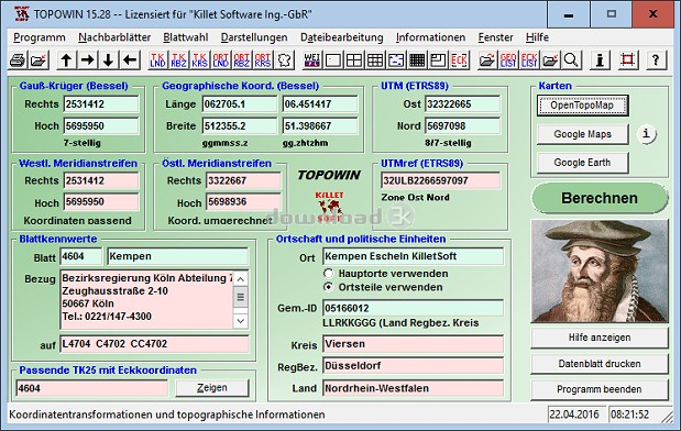
TOPOWIN is a state-wide register of the German Topographic Cartographies, the German Basic Cartography and of localities with geo references in different coordinate systems. It is also a topographic information system. In the division of planning and execution of economical and scientific projects frequently topographic documents are used. The program TOPOWIN makes information available of the official topographic cartographies and the German Basic Cartography from the entire national territory in suitable graphic views. It accomplishes different coordinate transformations and inquiries. The program was developed under co-operation of the land surveying authorities of many German Federal States. For the first time in the previous version TOPO (for DOS) and later in TOPOWIN state-wide topographic information were arranged for the data technical evaluation. The program is for consulting engineers, planning authorities and users of topographic maps a useful and versatile tool. The topographical maps of different standards, required for a project, can be determined by the entering of known parameters or by the direct selection from overview graphics and from sorted lists. By the investigation of topographical records on the basis of known places, a data base with more then 105.000 places and residential districts is available. The program TOPOWIN calculates with Gauss Krueger coordinates and Geographic Coordinates refering to the Potsdam Datum (Bessel ellipsoid with central point Rauenberg). It also works with UTM coordinates and UTMRef coordinates in the NATO standard, which refer to the datum ETRS89 (GRS80 / WGS84, geocentric).Requirements: Pentium, 50 MB HD
What's new in this version: 4700 new town districts of Lower Saxony added. All data applied updated to the data status January 1, 2025. View of maps in OpenTopoMap, Google Maps, Google Earth. All map views supplemented with UTM edge coordinates. Output of window contents in GIF and BMP files.
Antivirus information
Download3K has downloaded and tested TOPOWIN on 9 Apr 2025 with some of Today's best antivirus engines and you can find below, for your convenience, the scan results:
-
Avast:
Clean -
Avira:
Clean -
Kaspersky:
Clean -
McAfee:
Clean -
NOD32:
Clean

Popular downloads in Business & Finance
-
 Website Builder 9.0
This web site builder gives you everything y -
 PDF to Word | Solid Converter 10.1
Convert PDF to Word -
 Real Estate Price Calculator 3.0.1.5
Lands area length converter price calculator - Face Recognition System 2.0
Matlab source code for Face Recognition. -
 WPS Office Free 12.2.0.20326
Perfect free for creating & editing documents -
 to DBF Converter 3.16 - Allows you to convert XLS files to DBF format") XLS (Excel) to DBF Converter 3.16
XLS (Excel) to DBF Converter 3.16
Allows you to convert XLS files to DBF format -
 vCard Wizard 4.25
Transfer any Contacts. vCard vcf converter - Bill Maker 1.0
Bill, Invice, Inventory management -
 OEE 2
OEE 2
OEE calculator for MS Excel -
 Foxit Reader 10.0.0.35798
Protects Against Security.The Best PDF Reader
User rating
1.5/5 (3 votes)
Poor
Your rating
-
OS
Win2000,WinXP,Win7 x32,Win7 x64,Windows 8,Windows 10,WinServer,WinOther,Windows2000,Windows2003,Wind -
License
Shareware -
Price
$125 Buy -
Updated
4/9/2025 -
Downloads
951 (1 last week) -
Size
4.76 MB -
MD5
3ec79dbc95c4e674b7b9b0a782eaca74 -
SHA1
735d7be8b132d1ef6f561b07295950588cc0326a -
Developer
Killet GeoSoftware Ing.-GbR